1
A number preceded by a dot.
Show SolutionHide Solution↓
Spot height
ICSE Class 10 Geography · Total Geography · 26 solved questions
A number preceded by a dot.
Spot height
The numerical difference between two contour lines.
Vertical interval
A number preceded by a triangle.
Triangulation point
The difference between maximum and minimum height in areas of steep slope.
Relative height
The accurate height of some point marked above the ground.
Bench mark
Contour Interval
Contour interval means the difference of height between two consecutive contours. For example, if one thick contour shows the height 300 metres and the next thin contour depicts the height of 320 metres. Then, the contour interval is 20 metres.
Vertical Interval
The vertical distance between any two contour lines is called vertical interval.
Horizontal Equivalent
The actual distance between two points on two contour lines is called horizontal equivalent.
Gradient
The ratio between the vertical height and the horizontal distance of a slope of land measured along the ground is called gradient.
Gentle Slope and Steep Slope
| Gentle Slope | Steep Slope |
|---|---|
| In gentle slopes, the change of elevation is gradual. Normally about 1:25 gradient of elevation is gradual. | Steep slope suddenly slopes up or down. |
| The contour lines are widely spaced. | The contour lines are closely spaced. |
Scarp and Dip
| Scarp | Dip |
|---|---|
| A scarp has a narrow top with a steep slope. | A dip has a narrow top with a gentle slope. |
| The contour lines are closer to each other. | The contour lines are spread far apart. |
| It has a gradient of 1:3. | It has a gradient of about 1:12. |
Peak and Depression
| Peak | Depression |
|---|---|
| The highest point of a mountain is called a peak. | A depression is a low-lying area surrounded by higher land. |
| The contours are almost circular, with the peak at the centre. The contour values increase towards the centre, and the peak is represented by a spot height. | The contours are almost circular, with the depression at the centre. The contour values increase towards the centre and then decrease at the central depression, indicating a hollow or basin. |
What is meant by 'relief'?
Relief refers to actual configuration of land which includes its altitude and slope. The relief features found on the earth's surface include mountains, valleys, hills, plains and plateaus.
State the three methods used to show the earth's relief features on a map.
The three methods used to show the earth's relief features are-
What is a 'contour'?
Contour lines are imaginary lines which are drawn on a map to join places having the same height above the mean sea level.
What do the contour lines represent?
Contour lines are imaginary lines joining places which have the same height above mean sea level.
What advantages do contours have over hill-shading and hachuring?
Hill shading and hachuring only give an impression of the slope but do not indicate the heights of the land above sea level, whereas the contours show both impression of the slope as well as the heights of the land above the sea level.
How do contour lines show different slopes of land?
The contour lines are shown by brown colour as thick brown lines and thin brown lines. Contour lines show:
1. Elevation of land: The height of a contour is indicated by figures inserted in a break in the line.
2. Steepness of its slope: When the contours are very close, they represent steep slopes. When they are farther apart, they represent gradually increasing slopes. Absence of contour lines indicate that the land is flat i.e., a low land.
3. Shape of land at various heights: The contour lines indicate the shape of land. For example, almost circular contours whose value decreases inside represent a lake.
What do you understand by V.I. and H.E.?
V.I. stands for vertical interval. It is the vertical distance between any two contour lines.
H.E. stands for horizontal equivalent. It is the actual distance between two points on two contour lines.
Give two points of difference between Bench Mark and Spot Height.
| Bench Mark | Spot Height |
|---|---|
| These are marks etched on stone or a building to indicate the accurate height determined by surveys. | It refers to the height of a point on the ground above the mean sea level. |
| It is written as "BM" followed by a number. | It is represented by a dot followed by a number on the map. |
Why do the contour of different heights not cross each other?
Two contours of different heights never cross each other because each contour line represents a specific height above mean sea level, and a single point on the ground cannot have two different heights at the same time.
How do the contour lines show the direction of the flow of rivers and streams?
Rivers and streams usually flow from contours representing higher elevations to lower elevations. Since contour lines indicate the elevation and slope of the land, they help us determine the direction of flow of rivers and streams. The course of a well-developed river can be divided into three stages — upper, middle and lower course; each of which can be recognised with the help of contour lines.

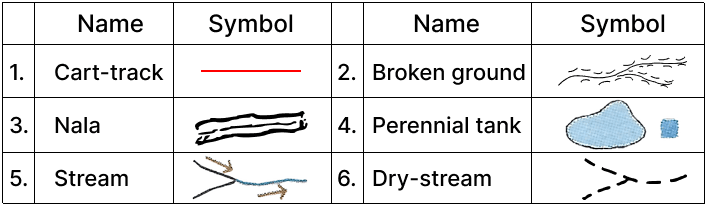
Given below are some symbols and conventional signs, name each one:

Complete the following by drawing the conventional sign/symbol in the blank boxes:


Draw conventional symbols for the following using appropriate colours where necessary.
(i) Cart-track
(ii) Broken ground
(iii) Nala
(iv) Perennial tank
(v) Stream
(vi) Dry-stream
Draw and compare the following contour diagrams by placing them side by side in pairs:
(a) V-shaped Valley and U-shaped valley
(b) Steep Slope and Gentle Slope
(c) Conical hill and mountain
(d) Ridge and Water Divide
(a) V-shaped Valley and U-shaped Valley
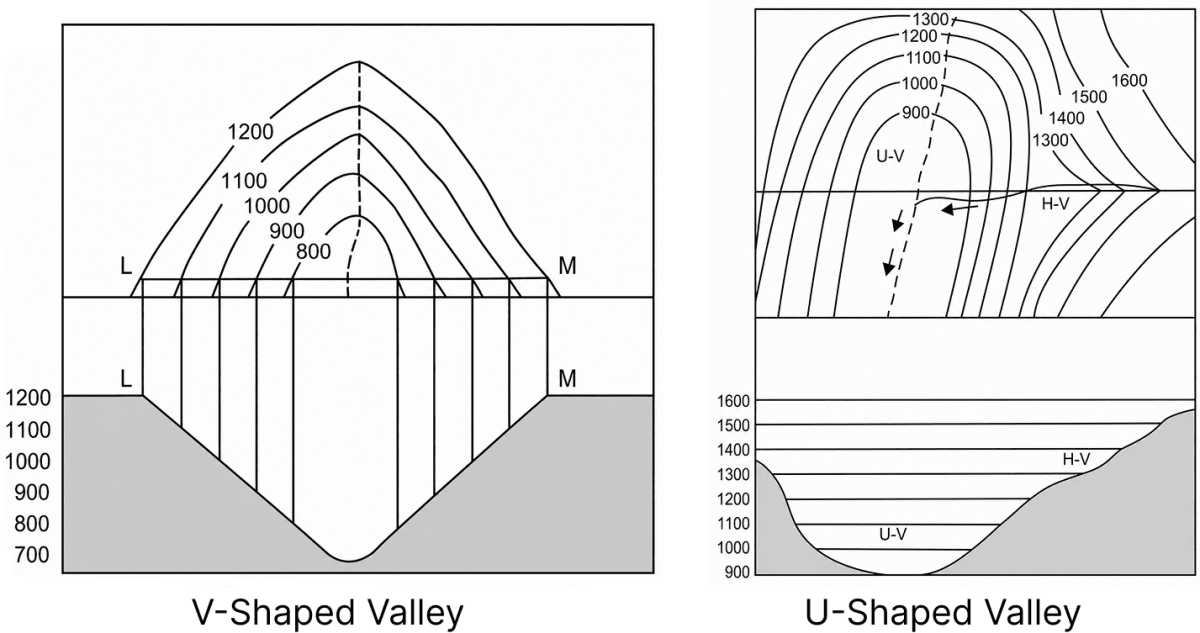
| V-shaped Valley | U-shaped Valley |
|---|---|
| It is formed in the upper course of a river, where the two sides of the valley are very close and steep with hardly any flat land between them. | It is a broad, flat-floored valley formed in the middle course of a river, or by the action of glaciers. |
| The contour lines are drawn in an inverted V-shape, their values decreasing inward. | The contour lines are broad and rounded (U-shaped), their values decreasing inward. |
(b) Steep Slope and Gentle Slope
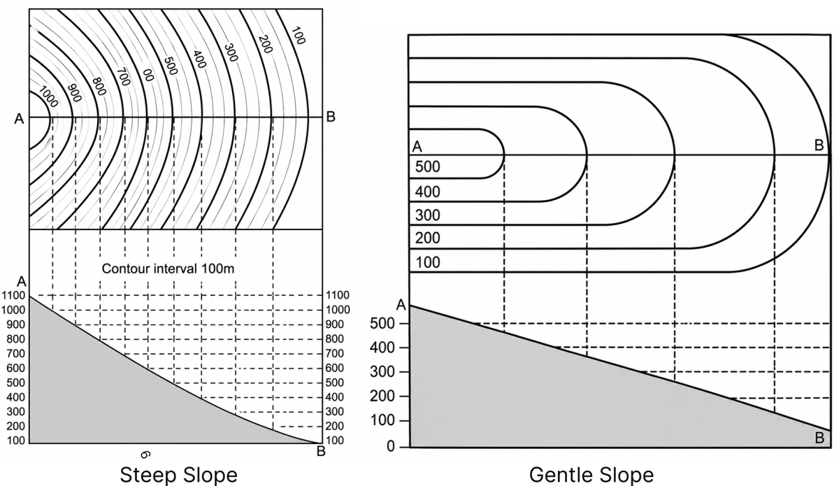
| Steep Slope | Gentle Slope |
|---|---|
| When the land suddenly slopes up or down, it is known as a steep slope. | In a gentle slope the change of elevation is gradual (normally about a 1:25 gradient). |
| The contours are drawn close to one another. | The contours are placed wide apart. |
(c) Conical Hill and Mountain
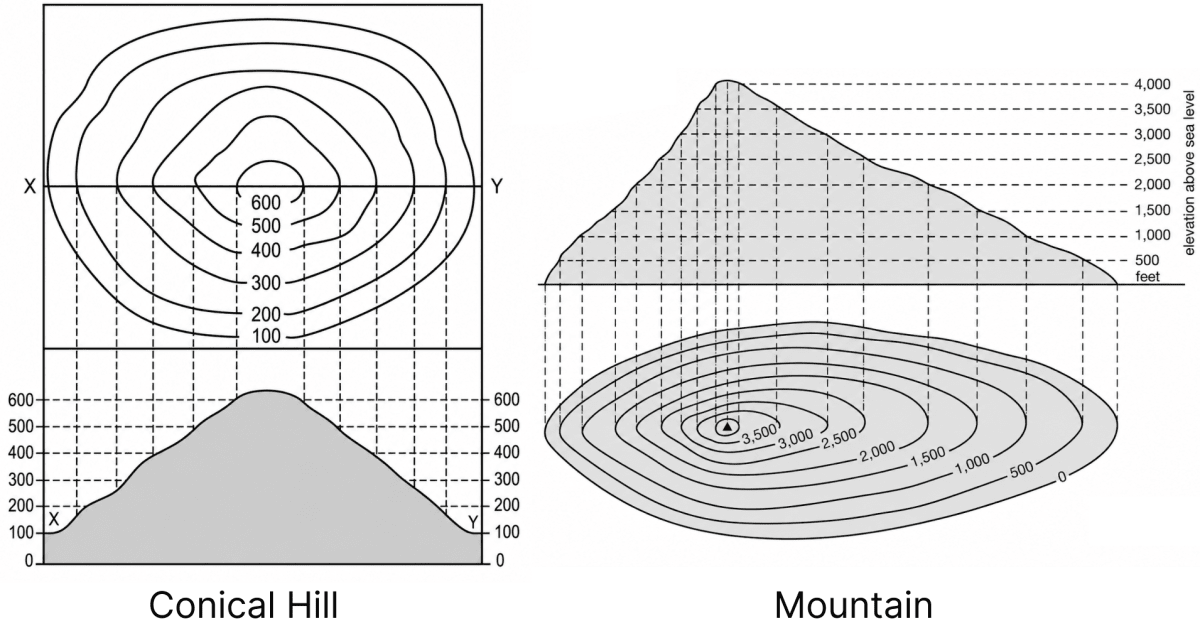
| Conical Hill | Mountain |
|---|---|
| A conical hill is like a cone with a broad base and its slope is almost the same on all sides. | A mountain is higher in elevation than a conical hill. |
| The contours are almost circular with the peak of the hill as their centre, drawn almost at regular distances, the value of which increases towards the centre. | It is represented by a larger number of contour lines than a conical hill, showing its greater height. |
(d) Ridge and Water Divide
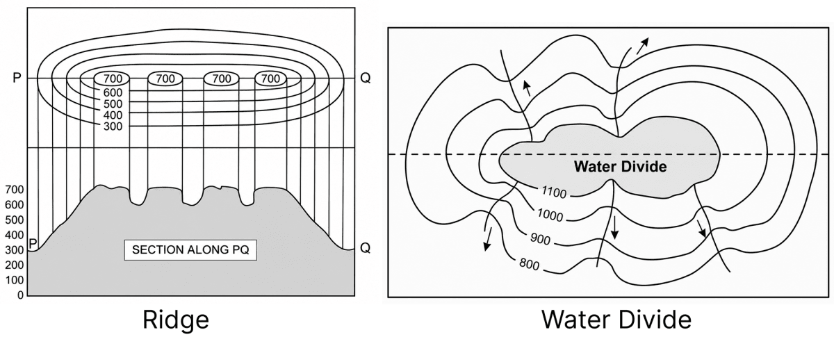
| Ridge | Water Divide |
|---|---|
| It is a long and narrow highland sloping steeply downwards on its sides. | It is a line which separates two adjacent drainage basins. |
| The contours showing a ridge are elongated and closely spaced. | It resembles a ridge; on the side where the slope is steeper the contours are drawn closely together, whereas on the side where the slope is gentle the contours are drawn far apart. |
Press ↓ to reveal a solution and move to the next question. Back to Total Geography.